Most Beautiful Day Hikes & Kayaking Areas in Lake Tahoe
Lake Tahoe, California and Nevada

National Forest Beaches, Lake Tahoe

Lower Eagle Falls, Lake Tahoe

Horsetail Falls, California

National Forest Beaches, Lake Tahoe
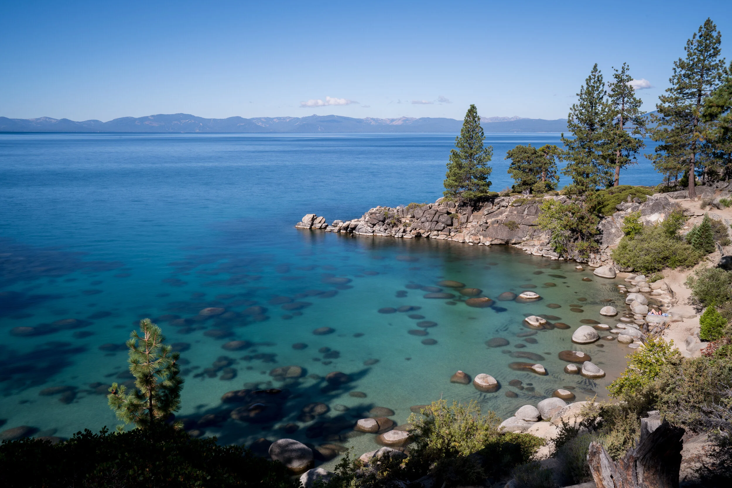
The Caribbean isn't the only place that has clear blue and turquoise colored water. In fact, you don't even need to be in salt water at all - just head to Lake Tahoe. Not only is Lake Tahoe one of the oldest and deepest lakes in the world, but it's also one of the most beautiful. The water is so clear that you can even see between 70 and 100 feet down! Top this off with a few beautiful nearby waterfalls, Lake Tahoe belongs on everyone's bucket list. This guide provides general travel tips for visiting Lake Tahoe and a list of the most beautiful hikes and areas to kayak there.
General Travel Tips
We recommend visiting Lake Tahoe during the warmer months of the year - July and August. It's so hot that time of the year that the ice cold water will feel perfect to jump into after a long day of hiking or kayaking.
Since you can circle the lake in a few hours and the locations below are somewhat spread out, find lodging/camping that's somewhere along the roads that circle the lake.
If there's clouds out, Lake Tahoe is one of the best places to watch a sunset, so be sure to be near the lake when it happens.
Do not leave food/drinks, empty food/drink containers including coolers, or anything with a scent in your vehicle. Lake Tahoe is an active bear area and bears have been known to break into vehicles. The same goes for camping - keep anything with a scent in the provided bear lockers and never bring it into your tent.
Be sure to grab some coffee, scones, and sandwiches at the West Shore Market - we promise you won’t regret it!
If you’d like to find your own little private cove, opt for hiking around the National Forest Beaches as described in the next section below. There’s plenty of coastline there, you just have to explore a bit more to find your own space.
Most Beautiful Day Hikes & Kayaking Areas
National Forest Beaches of the East Side (hiking): Along route 28 there's a tiny parking area that you can find in google maps by typing in "Secret Harbor Parking Lot." If there’s parking available, park here and take the dirt fire road all the way down to the lake. Otherwise, head South on Route 28 from this parking area about 0.5 miles and find a safe spot to pull over and park on your right. On the right side of the road, you'll see a spider web of hiking trails that will eventually connect to the dirt fire road. Take these trails to the fire road and continue south on the fire road to the end where you'll see a small hiking trail that follows the coastline. Explore the entire coastline - there are tons of spectacular beaches and coves! The following beaches can be found along this hike: Chimney Beach, Secret Cove, Secret Harbor Beach, Creek Beach, and Whale Beach. Be aware that several of the beaches are clothing optional.

National Forest Beaches, Lake Tahoe

National Forest Beaches, Lake Tahoe

National Forest Beaches, Lake Tahoe

National Forest Beaches, Lake Tahoe
National Forest Beaches, Lake Tahoe
Skunk Harbor (hiking): Exactly 5 miles South of Sand Harbor on Route 28 you’ll find space to park along the right side of the road. Take the fire road down to the beach. It’s about a 3 mile roundtrip hike. There you’ll find a few small beautiful beaches and an old abandoned house that was built back in the 1920s. There’s not many well developed hiking trails beyond the area around the house, so what you see is what you get - but it’s still worth it.

Skunk Harbor, Lake Tahoe

Skunk Harbor, Lake Tahoe

Skunk Harbor, Lake Tahoe
Bonsai Rock & East Side Coves (kayaking): If you're more of kayaker, want an arm workout, or are just that motivated to see more of these beautiful coves, then this one is for you. Head out early the morning to Sand Harbor along route 28. If you don't head out early, this place fills up super quick and you will be disappointed because they close the gates once the lot is full. You can rent a kayak here all day for about $80. Bring a waterproof backpack with some food, a good amount of water, sunscreen, and of course, your camera. Kayak out of Sand Harbor and then head south. There's no need to hug the coastline until after you pass the beaches of Sand Harbor. Once you pass the beaches, start to kayak along the coastline and as you head south, you'll reach Bonsai Rock. It's a cool rock with some small trees growing on it, but even better is the larger rock island right next to it. This place is a true nature lovers playground. Park your kayak and have a blast. If that's not enough for you, jump back in your kayak and continue heading south. Eventually you'll pass the Thunderbird Lodge Preservation - it's the only built structure you'll see along the way. Once you pass the preservation, hug the coastline again and you'll find gorgeous coves and might even be able to score one all for yourself. I would use Chimney Beach (there's a real chimney on the beach) as your turnaround point and head back to Sand Harbor from there. That will have been several hours worth of kayaking.

East Side Coves, Lake Tahoe

East Side Coves, Lake Tahoe
Emerald Bay & Lower Eagle Falls (hiking): Head out early to the Emerald Bay State Park parking area along route 89. This is another one that can fill up quickly if you wait until the afternoon to go. From the parking area, walk to the viewpoint where you'll see a great view of Emerald Bay. Look to your right, you'll see a huge waterfall flowing down the mountainside - this is the one you'll be hiking to, Lower Eagle Falls. You can hike down to the lake from here and find your way up to the waterfall from the lake. This hike is about two miles roundtrip.
You can also scramble down the rocks on a trail that’s along the right side (when facing Emerald Bay) of Lower Eagle Falls for an even closer view. To get to this hike, drive further north up the road and park near the trailhead for (upper) Eagle Falls. Directly across the street from the parking lot for Eagle Falls is where you'll be heading. After crossing the street, you can scramble down the rocks on a trail that’s to the right of the waterfall. Know that the rocks can be very very slippery and please only take this route if you have some experience scrambling down larger rocks. This is obviously dangerous and if you make a mistake, it could be your last…so be careful. After you reach the first part of the waterfall, continue heading down to the second part. Both parts are equally beautiful and it's definitely worth it to see both. This hike is less than one mile roundtrip.
If you're looking to kill more time here, you might also want to hike the trail that starts at the Eagle Falls parking area. This will bring you to a less spectacular waterfall than you've just seen, but there is a little natural pool of water to dip in and if you go a bit further, you can even get to Eagle Lake. The round trip distance to Eagle Lake is approximately 2 miles.
Finally, if you don’t mind a passing car shining its high beams here and there, Emerald Bay is great and convenient place to stargaze. If the moon isn’t out, you can even see the Milky Way on a clear night!

Lower Eagle Falls, Lake Tahoe

Lower Eagle Falls, Lake Tahoe

Emerald Bay, Lake Tahoe

Emerald Bay, Lake Tahoe

Emerald Bay, Lake Tahoe
Horsetail Falls (hiking): Depending on where you’re staying in Lake Tahoe, it can take up to 1.5 hours to reach the trailhead of this 4 mile roundtrip hike. Don’t let the drive scare you though - this waterfall rivals that of waterfalls in Yosemite. Not far from the trailhead, you’ll get a good view of the entire waterfall in the distance, all the way from the top of the mountain and down to the river you’ll be hiking next to. It is spectacular! The trail can be a bit challenging to find at times, so I’d recommend downloading the All Trails app and downloading their offline map for the Horsetail Falls Trail in Desolation Wilderness - instructions on how to download offline maps on the app can be found HERE. Worst case scenario, follow the river up to the waterfall. As this is a popular hike and the parking lot has limited capacity, I’d try to reach the parking area by at least 7:30am. Be sure to purchase a parking permit for your car at the kiosk. Once you get to the base of the waterfall, don’t forget to dip into the awesome little ice cold pool of water. For those looking for more of a challenge, you can find a way to scramble all the way to the top of the waterfall - it’ll kick your butt.

Horsetail Falls, California

Horsetail Falls, California

Horsetail Falls, California