Most Beautiful Day Hikes in Moab
Moab, Utah

Dead Horse Point State Park, Moab

Arches National Park, Moab

Goblin Valley State Park, Moab

Arches National Park, Moab
Arches National Park, Moab

Canyonlands National Park, Moab

Corona Arch, Moab
Arches National Park, Moab

Goblin Valley State Park, Moab
If you’re into amazing canyons, huge arches you can walk through, cliffside views, other-wordly geological formations, firey red rocks during sunset, nature for as far as the eye can see, and high desert climates without much vegetation, then Moab is for you. This guide includes the most beautiful day hikes in and around the Moab area including: Arches National Park, Canyonlands National Park, Dead Horse Point State Park, Goblin Valley State Park, and land managed by the Bureau of Land Management (BLM).
General Travel Tips
Because Arches National Park is so popular and has limited parking, we highly recommend visiting during the winter months. Check the weather and driving conditions before you go - you don’t want to be driving during an ice storm.
If you do decide to visit in the winter, be sure to have the appropriate winter gear: moisture wicking base layer so you don't get cold after sweating on longer hikes (merino wool is great for this), down jacket, waterproof outer layer, wool socks, beanie, gloves, and microspikes (for any icy parts of the trail). Check out our gear page for our own gear recommendations, where to find the best gear reviews, and the best places to shop.
With the exception of Arches National Park, the parks on this page are remote, so bring extra water and food in your vehicle just in case you get stuck out there.
The day hikes listed on this page will look their best during sunrise or sunset.
If you’re looking for the most under appreciated and least crowded park on this page, it’s Goblin Valley State Park.
If you're going to visit both Dead Horse Point State Park and Canyonlands National Park, do both in the same day as Dead Horse is along the way to Canyonlands.
For great food, check out any one of these spots (we tried & loved each one): Antica Forma, Arches Thai, El Charro Loco, Love Muffin Café, Moab Spitfire Smokehouse, Sweet Cravings Bakery and Bistro.
Most Beautiful Day Hikes
Arches National Park: With over 2,000 arches, this park was named appropriately. Below are the most beautiful arches to see in the park. You can find a map of the park HERE. The park is open 24 hours and is 15 minutes from Moab.
Double Arch: Take Windows Road off Main Park Road and park at the trailhead for Double Arch (it’s immediately after the parking for The Windows trailhead). Half mile roundtrip hike.
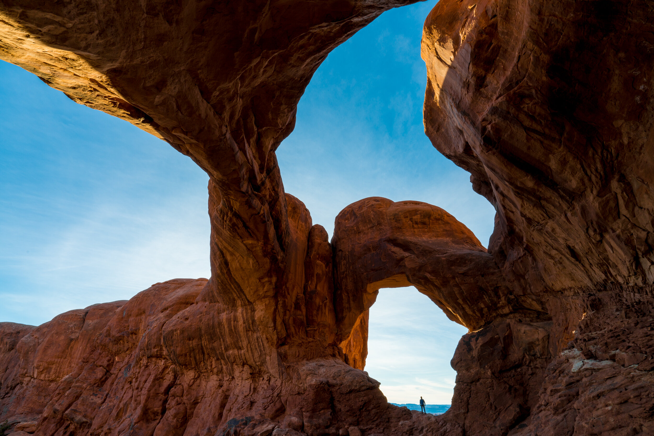
The Windows and Turret Arches: Same directions as above. Hike through the first window arch you see from the parking area and look back through the arch to see a perfectly framed Turret Arch. Slightly over 1 mile roundtrip hike.
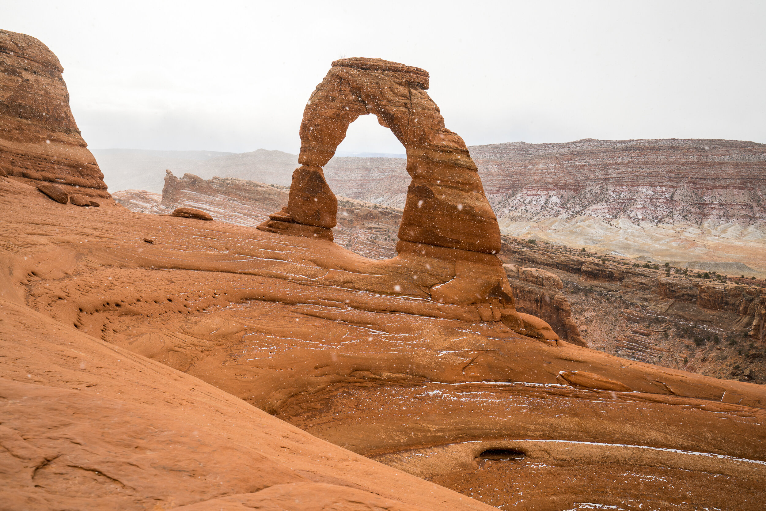
Delicate Arch: To find the trailhead, take Delicate Arch Road off of Main Park Road. 3 mile roundtrip hike. Be sure to follow the cairns (small stacks of rocks) to stay on the correct trail.
Navajo and Double O Arch: Park at the Devil's Garden parking area at the very end of the park. Take the Devil's Garden Trail to the Devil's Garden Primitive Loop. Follow the signs to see Navajo Arch which is a half mile roundtrip hike from the start of the Primitive Loop. Being very careful to look for and follow the cairns, continue on the Primitive Loop to see the Double O Arch. Navajo Arch - 3 mile roundtrip hike. Double O Arch - little over 4 mile roundtrip hike (1 more mile roundtrip from Navajo Arch).
Tower Arch: 16 miles from the park entrance, take Salt Valley Road (dirt road, but normal cars should be able to take the road), then hang a left onto Klondike Bluffs and park at the end of the road. Hike the Klondike Bluffs Trail to reach the arch. Be careful to follow the cairns, it's easy to lose the trail here. 2.5 mile roundtrip hike.

Double Arch, Arches National Park

Double Arch, Arches National Park

Double Arch, Arches National Park

Window and Turret Arch, Arches National Park

Turret Arch, Arches National Park

Delicate Arch, Arches National Park

Delicate Arch, Arches National Park

Delicate Arch, Arches National Park

Navajo Arch, Arches National Park | Photo by John Kovalsky
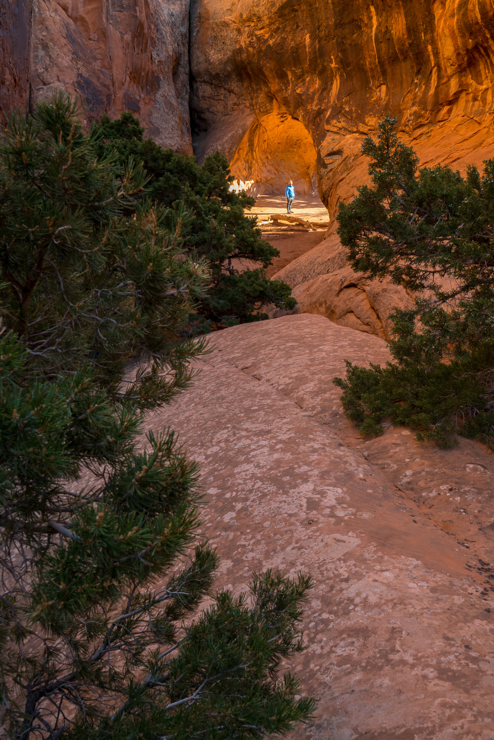
Navajo Arch, Arches National Park

Double O Arch, Arches National Park

Tower Arch, Arches National Park

Tower Arch, Arches National Park

Tower Arch, Arches National Park
Deadhorse Point State Park: Park at Dead Horse Point and take the 2.5 mile West Rim Trail. You can find a map of the park HERE. The park is open from 6am to 10pm and is 45 minutes from Moab. Since Deadhorse is along the way, we highly recommend visiting Canyonlands National Park (below) in the same day.

West Rim Trail, Dead Horse Point State Park

West Rim Trail, Dead Horse State Park

West Rim Trail, Dead Horse State Park

West Rim Trail, Dead Horse Point State Park

West Rim Trail, Dead Horse Point State Park
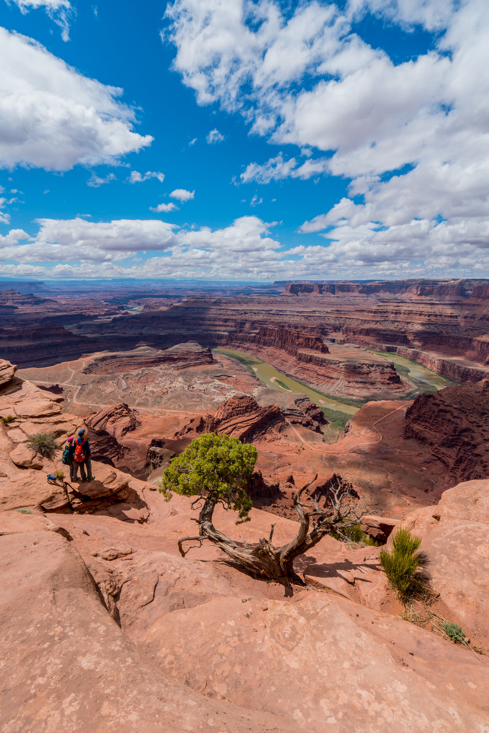
West Rim Trail, Dead Horse Point State Park
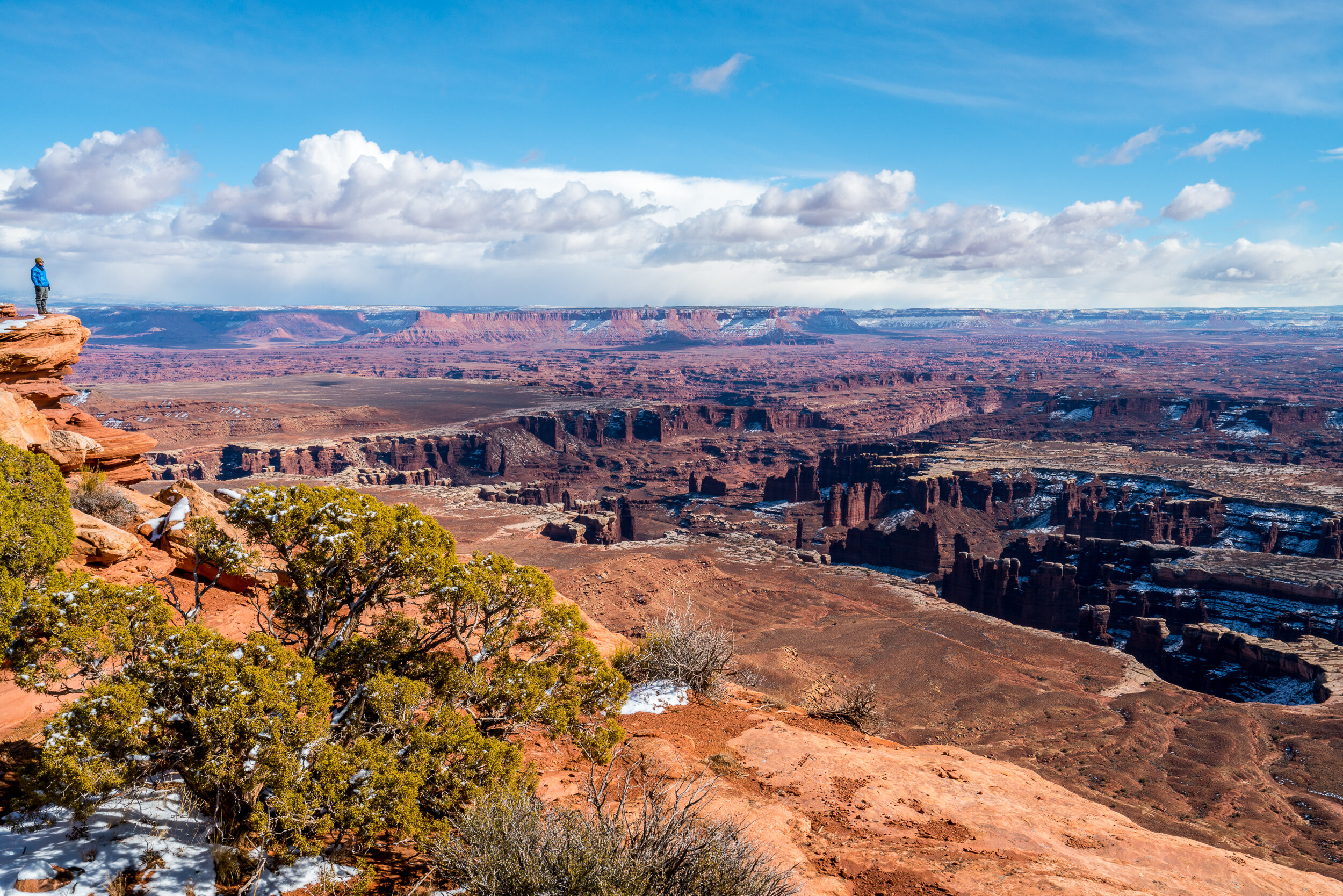
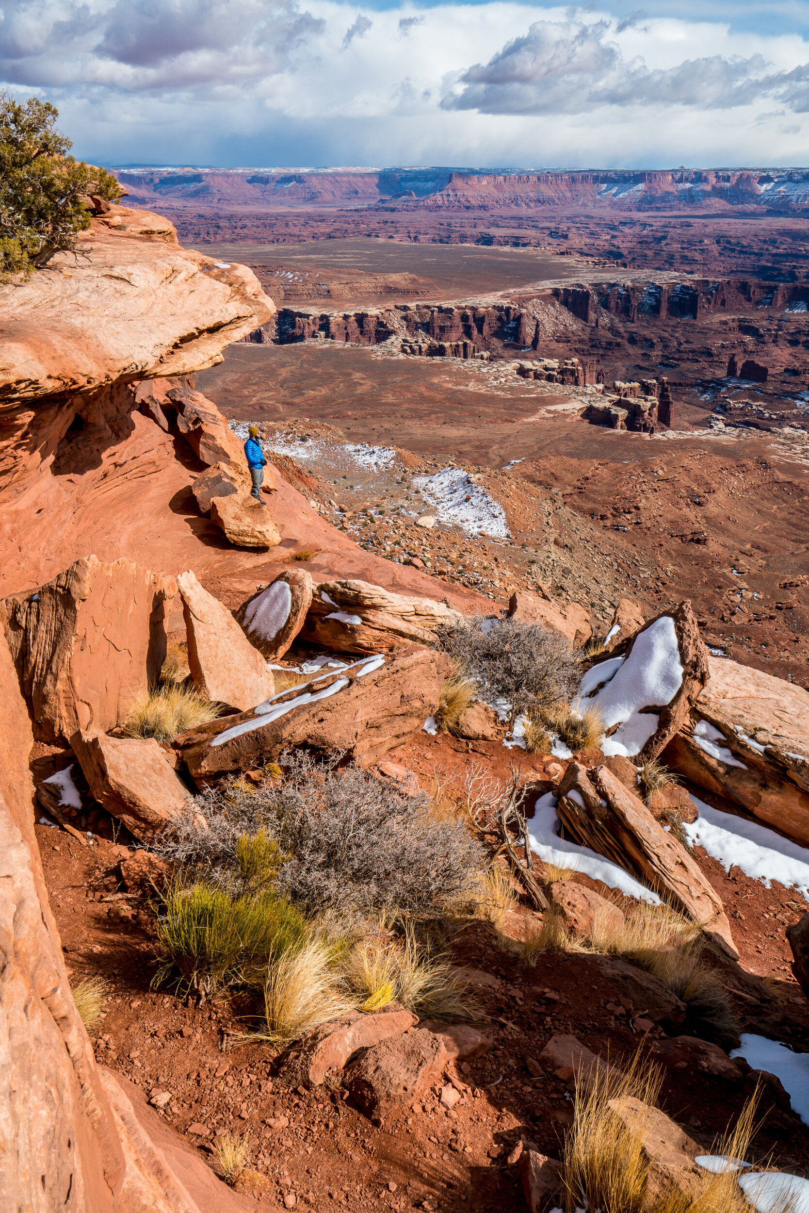
Canyonlands National Park: Every hike in this park provides the most amazing viewpoints of vast canyons. Below are the most beautiful hikes that are all located in the Island of the Sky district of the park. You can find a map of the park HERE (see Island in the Sky Trails and Roads). The park is open 24 hours and is 45 minutes from Moab.
Grand View Point: Park at the end of Grand View Point Road. 2 mile roundtrip hike.
Green River Overlook: Just a 10 minute drive northwest from grand view point at the end of Green River Overlook Road. Be sure to hike up the hill to the right of the parking area to reach better cliffside views. Half mile roundtrip hike.
Mesa Arch: Not far east from Green River Overlook, this will be one of the most popular spots in the park, so don't expect much solitude here - but the views are well worth it! Half mile roundtrip hike.
Grand View Point, Canyonlands National Park

Grand View Point, Canyonlands National Park
Grand View Point, Canyonlands National Park

Green River Overlook, Canyonlands National Park

Green River Overlook, Canyonlands National Park

Green River Overlook, Canyonlands National Park

Green River Overlook, Canyonlands National Park
Goblin Valley State Park: Park at Observation Point and explore the area immediately in front of the parking area. You can hike as little or as much as you'd like here for views that suit your preference. If you’re into caves, be sure to hike the 3 mile roundtrip trail called Goblin’s Lair, it starts to the far left of the parking area at Observation point. You can find a map of the park HERE (under Brochures). The park is open from 6am to 10pm and is 1 hour 40 minutes from Moab.

Goblin Valley State Park

Goblin Valley State Park

Goblin Valley State Park

Goblin Valley State Park

Goblin’s Lair, Goblin Valley State Park

Goblin’s Lair, Goblin Valley State Park
Corona Arch: Use your GPS to navigate to the Corona Arch trailhead. Watch for cairns and green arrows on the ground to be able to follow the correct hiking trail. This hike involves one short ladder and a few cables you'll need to hold onto in a few spots. Located on BLM land, this area is open 24 hours and is 20 minutes from Moab.

Corona Arch

Corona Arch

Corona Arch